Cadcorp
- Founded: 1991
- 01438747996
- Sterling Court, Norton Road, Stevenage, SG1 2JY
- info@cadcorp.com
- Geographical information systems (GIS) and mapping
- Plan-making, planning application and data management systems
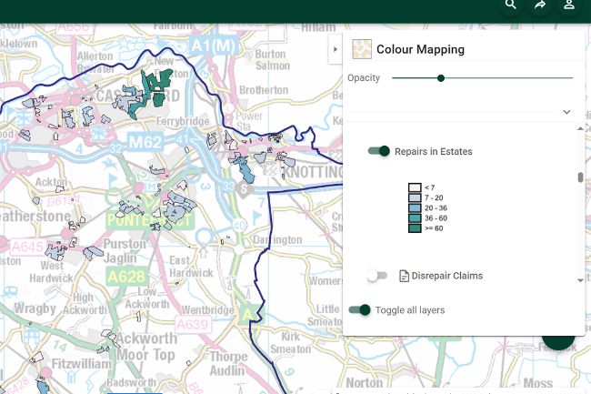
- Customisable Dashboards
- Live chat / help lines
- Mobile applications
- Training and support
Introduction
Cadcorp helps organisations derive meaningful and actionable intelligence from data. We do this with an extensive range of GIS software, spatial data and consultancy services designed to better inform decision-making. With our technical knowledge and expertise, we know how to support our customers in realising the benefits of location information.
Organisations are extracting greater value from data to meet future service needs and help communities make informed choices. Cadcorp software and services enable organisations to query and display location-based information for day-to-day tasks and evidence-based work that assists long-term policy. It provides easy access to geographic information that can be shared across departments and directly with the public on a self-serve basis. Location intelligence can highlight critical evidence for informing the planning of service provision.
If you require GIS software, spatial data, or services, Cadcorp can help.
Cadcorp offers an integrated family of geospatial software – Cadcorp SIS. This comprises desktop, server, web, and mobile products and has been designed for use in all phases of spatial data management.
Cadcorp partners with data suppliers to license a wide range of spatial data. We are an Ordnance Survey® Premium Partner with over 25 years of experience working with OS® data.
Cadcorp services are designed to guide and support the organisation’s geospatial strategy. These can range from spatial data updates to cloud hosted managed services, from quality assurance to managing the GIS and web mapping software.
Our products
-
 Cadcorp Call for Sites
A digital site assessment application that allows landowners, developers, agents, and site promoters to suggest sites for future development. Sites can be proposed online on a web map. Then, after completing an application form, the site proposal can be submitted electronically, with supporting documentation, to the council.
-
 Cadcorp SIS Desktop
SIS Desktop provides a full range of GIS functionality including data creation, querying, analysis and modelling. SIS Desktop provides extensive data format support including Ordnance Survey® spatial data.
-
 Cadcorp SIS WebMap
An easy-to-use off-the-shelf GIS application for internet and intranet web mapping. It includes facilities for presenting and interrogating GIS spatial data and is accessed through a familiar and mobile responsive web mapping interface.
Case studies


Cadcorp Call for Sites
Testimonials
"The Cadcorp Call for Sites application has saved us on average, 6 hours in staff time per site submitted."
“The Cadcorp Call for Sites platform will be pivotal to the department in fulfilling its aims, as the platform is easy for all to use ... By streamlining this process, we will save time and money, which will afford our planning department greater access to both as valuable resources.”
“We needed a cloud hosted and fully supported GIS and spatial database solution. Following a G-Cloud supplier review, it became obvious that Cadcorp offered the best overall fit with our requirements.”