UK-wide
LUC
At LUC, we aim to make a difference. With 58 years at the forefront of environmental consultancy, we want to deliver better futures for nature, people, and places.
Our holistic services tackle complex land use problems, and our creative, forward-thinking professionals are passionate about addressing the climate and biodiversity crises.
Company:
- Founded: 1966
- 12th Floor Beacon Tower, Colston Street, Bristol, BS1 4XE
- diana.manson@landuse.co.uk
Service areas:
- Community engagement
- Visualisation, 3D modelling and animations
- Geographical information systems (GIS) and mapping
- Planning and urban design services
- Land search and assessment
Introduction
LUC is an award-winning environmental consultancy providing planning, impact assessment, landscape design, geospatial and ecology services to a wide range of public and private sector clients. Our mission is simple: to deliver better futures for people, nature and places. With a track record of over 55 years, our holistic services tackle complex land use problems, and our creative, forward-thinking professionals are passionate about addressing the climate and biodiversity crises. We’ve always tried to balance the need for change with the needs of the environment and local communities and make a positive difference for all. We deliver a range of planning and assessment services, all supported by our GIS and Visualisation team.
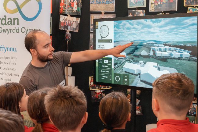
Ensuring that information is accessible to everyone is not just a requirement, it’s a responsibility. LUC’s digital approach has led to the creation of accessible digital evidence reports that efficiently integrate diverse datasets, offering planners a holistic view and supporting the plan-making process. Use of digital tools to generate interactive mapping and 3d visualisations empowers planners and stakeholders to make informed decisions. We’ve developed digital consultation tools to foster engagement with a wider, non-technical audience and collaboration between planners and other users, encouraging a more transparent planning process.
Ensuring that information is accessible to everyone is not just a requirement, it’s a responsibility. LUC’s digital approach has led to the creation of accessible digital evidence reports that efficiently integrate diverse datasets, offering planners a holistic view and supporting the plan-making process. Use of digital tools to generate interactive mapping and 3d visualisations empowers planners and stakeholders to make informed decisions. We’ve developed digital consultation tools to foster engagement with a wider, non-technical audience and collaboration between planners and other users, encouraging a more transparent planning process.
Case studies

LUC – Delivering better futures for Nature, People & Place
Testimonials
An exceptional team and we look forward to working with them again in the future. The ability to manage complex GIS and development of a public access web mapping system alongside all the other aspects of the project including 'on the ground' surveys was fully appreciated.
James Bisset
Herefordshire Council
LUC understood our needs and brought extensive knowledge of the Scottish planning system. They present robust technical data in a high-quality, visual way.
Jillian Adams
BayWa r.e. UK
Industry recognition
Award
Planning Consultancy of the Year - Highly Commended
2024
Award
RTPI Scotland Awards for Planning Excellence - Best Project
2023
Award
Employee Owned Business of the Year
2023
Award
Scottish Renewables Green Energy Awards - Sustainable Development Award
2023
Award
RTPI Awards for Planning Excellence - Planning Consultancy of the Year
2022
Find out more about pricing
The services we offer integrate and evolve to create the right team for every project. We stand by the approach of our founders to "understand first, act second". Using rigorous insight and robust data, we help to make sense of our environment.
Useful links
LUC's Photomontage and visualisation service
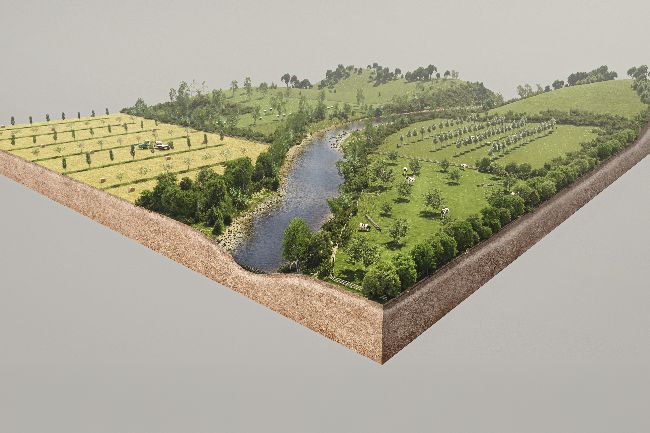
Our visualisations illustrate a proposal’s likely landscape and visual effects, and help the decision-maker/competent authority understand these effects. We visualise both rural and urban landscapes, at various levels of detail – from basic block models to fully rendered 3D models.
Visit external link
LUC Digital reports and online engagement tools
Our team develops dedicated project websites for key stakeholders. We design the content to reflect the objectives of the project as well as the wide-ranging technical abilities of the audience. Features include online surveys, interactive mapping, and virtual whiteboards.
Visit external link
LUC Mapping & data analysis services
One of our clients’ major challenges is presenting complex spatial datasets in a digestible way. We create interactive databases that set out data in maps or other graphical formats so patterns can be understood by a wide range of users.
Visit external link