
England,
UK-wide,
Wales
Blue Fox Technology Ltd
Blue Fox Technology provides digital mapping, GIS and cartographic services for output to different media, in particular accessible, online interactive maps. Developer of OpusMap: hosted interactive mapping software for users to make their own interactive maps from their own data.
Company:
- Founded: 1999
- 07484099198
- Blue Fox Technology Ltd, Carlton House, 68 Conway Road, Colwyn Bay, LL29 7LD
- david.cooper@bluefoxtech.co.uk
Service areas:
- Community engagement
- Geographical information systems (GIS) and mapping
- Planning and urban design services
- Plan-making, planning application and data management systems
- Organisational digital transformation
Technologies:
- Machine Learning
- Satellite Imagery
Features:
- Mobile applications
- Training and support
Introduction
SME with 20+ years experience in digital mapping, GIS and cartographic services.
Ordnance Survey Licenced Partner.
Specialises in the design, build and output of high quality maps to different digital and hard copy media.
Specialists in the design and production of accessible, user-friendly and customer-oriented online interactive maps from data maintained in GIS and other databases.
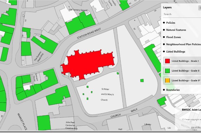
OpusMap is the company's hosted interactive mapping software, available to users under a SaaS licence.
Accessed through a standard web browser on desktop or mobile.
Used by LPAs and Local Plan teams in support of digital plan making, online stakeholder and community engagement and in the production of online interactive digital plans and maps from GIS and other digital sources.
Users have direct control of data input and output, map design and customisation and how final maps are configured for public access and interaction.
Functions as both an interactive online map publishing system and as a webGIS. Users can create bespoke interactive maps from their own data and configure how users interact with their maps and data.
Guarantees interactive maps and data are accessible on any device (desktop and mobile) and through any web browser.
Makes complex plans and maps more accessible and user-friendly thereby improving stakeholder engagement in digital plan making and planners in the overall plan making processes.
Planners tailor their digital mapping and data requirements to their in house workflows by providing a range of digital plan making tools and functions that ensure consistency in terms of output, access and functionality.
Ordnance Survey Licenced Partner.
Specialises in the design, build and output of high quality maps to different digital and hard copy media.
Specialists in the design and production of accessible, user-friendly and customer-oriented online interactive maps from data maintained in GIS and other databases.
OpusMap is the company's hosted interactive mapping software, available to users under a SaaS licence.
Accessed through a standard web browser on desktop or mobile.
Used by LPAs and Local Plan teams in support of digital plan making, online stakeholder and community engagement and in the production of online interactive digital plans and maps from GIS and other digital sources.
Users have direct control of data input and output, map design and customisation and how final maps are configured for public access and interaction.
Functions as both an interactive online map publishing system and as a webGIS. Users can create bespoke interactive maps from their own data and configure how users interact with their maps and data.
Guarantees interactive maps and data are accessible on any device (desktop and mobile) and through any web browser.
Makes complex plans and maps more accessible and user-friendly thereby improving stakeholder engagement in digital plan making and planners in the overall plan making processes.
Planners tailor their digital mapping and data requirements to their in house workflows by providing a range of digital plan making tools and functions that ensure consistency in terms of output, access and functionality.
Case studies

4 Reasons for using interactive maps
Testimonials
Having the ability to create our own maps in OpusMap for internal use as well as for public access is a great advantage. It speeds up our site assessment processes and allows us to extract and report candidate site data easily to present to the LDP working group.
Gayle Frewin
Planning Policy, Powys County Council
Find out more about pricing
Click on the URL below to find full details on OpusMap pricing, onboarding, ongoing support and full software technical specification.