Urban Intelligence
An open source data approach to tackling housing targets in Newcastle
An open source data approach to tackling housing targets in Newcastle
Details:
- Company: Urban Intelligence
- Client: Newcastle City Council
- Year: 2022
- Region: England
- Product: PlaceMaker
Service areas:
- Geographical information systems (GIS) and mapping
- Land search and assessment
- Plan-making, planning application and data management systems
Introduction
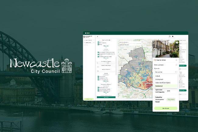
With a population passing 300,000 in the 2021 census, Newcastle City Council aims to deliver 19,000 homes by 2030 to serve its growing city. To deliver this, the council’s planning team adopted PlaceMaker, the platform for digital local plan making, to ensure the best development opportunities are unlocked for generations to come.
By incorporating open source data through PlaceMaker, Newcastle’s planners gained deeper insights into their communities, development opportunities, and constraints. This data is also enabling them to better understand capacity and density across the city, supporting them to consider how policy decisions are going to impact future housing delivery.
By incorporating open source data through PlaceMaker, Newcastle’s planners gained deeper insights into their communities, development opportunities, and constraints. This data is also enabling them to better understand capacity and density across the city, supporting them to consider how policy decisions are going to impact future housing delivery.
Challenges
When Newcastle City Council adopted PlaceMaker in 2022, it faced challenges familiar to many UK local authorities: a reliance on a patchwork of spreadsheets, systems, and manual processes. Kathy Verlander, Senior Planning Project Officer, explained, “We wanted software that could bring data together, all in one place,” eliminating the inefficiencies of managing spreadsheets and gathering data from various departments.
The need for accurate, up-to-date information was critical for identifying and assessing potential sites to meet development needs. Kathy highlighted how PlaceMaker’s ability to support a streamlined call for sites process and assess unregistered land was particularly appealing. “PlaceMaker can automatically assess all sites across our authority area,” she noted, enabling the council to address Newcastle’s constrained land supply and focus on densification strategies to meet their development targets.
The need for accurate, up-to-date information was critical for identifying and assessing potential sites to meet development needs. Kathy highlighted how PlaceMaker’s ability to support a streamlined call for sites process and assess unregistered land was particularly appealing. “PlaceMaker can automatically assess all sites across our authority area,” she noted, enabling the council to address Newcastle’s constrained land supply and focus on densification strategies to meet their development targets.
Solutions
PlaceMaker’s introduction allowed Newcastle’s planning team to implement streamlined processes immediately. The use of open source data in site assessments has been a “game changer”, Kathy explains, tasks which once required reliance on other departments, such as updating shape files, is now automated. “Previously, we would have to go to the libraries team and say, can you update shape files on existing libraries”. Now, she explains, her team have access to the latest data in each site’s Accessibility tab, including a host of transport and community facilities data relating to each site.
Whilst not reliant on other teams for data collection, plan-making is still incredibly collaborative. The unlimited users in PlaceMaker allows specialists from across the council to access the platform, input data and provide comments in a centralised system. This ensures information is organised, accessible, and no longer buried in email chains or outdated spreadsheets and PDFs.
Whilst not reliant on other teams for data collection, plan-making is still incredibly collaborative. The unlimited users in PlaceMaker allows specialists from across the council to access the platform, input data and provide comments in a centralised system. This ensures information is organised, accessible, and no longer buried in email chains or outdated spreadsheets and PDFs.
Results
Newcastle is now at the forefront of standardising capacity analysis for a robust, data-driven land availability assessment. As a member of the PlaceMaker community, this learning is shared with other PlaceMaker councils, championing best practices in digital planning and data standardisation. Working with Urban Intelligence, Newcastle has refined its approach to assessing residential capacity and density testing, to explore density at a more granular level. This data is enabling officers to more rapidly test different scenarios to think about housing delivery, considering prevailing densities and the impact of density uplift across certain areas of the city.
Reflecting on their progress, Kathy shared, “Having access to this pool of resources has been an amazing education and helped us move forward in digital local plan making. It has enabled us to think through what a ‘digital local plan’ really means and the different ways we can achieve that.”
Reflecting on their progress, Kathy shared, “Having access to this pool of resources has been an amazing education and helped us move forward in digital local plan making. It has enabled us to think through what a ‘digital local plan’ really means and the different ways we can achieve that.”
“What’s great about working with Urban Intelligence and the PlaceMaker software, is all the expertise that the team brings. It’s not just an off the shelf product…we wouldn’t have had access to the in-house resource and capabilities to the same degree before working with them.”
Kathy Verlander,
Senior Planning Project Officer, Newcastle City Council