City Science
- Founded: 2015
- +447515549270
- Clockwise | Broadwalk House | Southernhay West | Exeter | EX1 1TS
- Info@cityscience.com
- Visualisation, 3D modelling and animations
- Geographical information systems (GIS) and mapping
- Plan-making, planning application and data management systems
- Organisational digital transformation
- Digital twins
- Artificial Intelligence (AI)
- Machine Learning
- Satellite Imagery
- Customisable Dashboards
- Mobile applications
- Training and support
- Digital Outcomes 6 (DOS 6)
Introduction
A leading solution for Digital Plan-Making, Cadence combines cutting-edge GIS technology with a unique and intuitive user experience to deliver value from data faster.
As the trusted core data engine for cities and regions, Cadence empowers you to unlock the full potential of your data and people, driving informed decision-making and operational efficiency. With over 7,000 pre-curated datasets, Cadence is ideal for the production of robust Digital Baselines. With specialist tools such as automated workflows and lightning-fast visualisations, Cadence enables you to easily tackle complex spatial processes and datasets putting insights into the hands of those that need them.
With self-service capabilities and distributed workflows, Cadence modernises traditional GIS approaches, equipping all your teams with the data, visualisations and analytics they need for success.
Our products
-
 Cadence DataBank
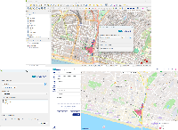
Cadence makes it easy to discover, visualise and analyse geospatial data with just a few clicks – no technical expertise required. As the most comprehensive collection of UK planning data available, Databank eliminates the barriers of accessing essential spatial information, putting the data you need at your fingertips.
-
 Cadence Stories
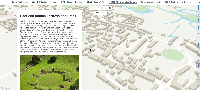
Cadence makes it easy to design, build and publish interactive stories that seamlessly combine maps, text and images to bring locations to life. Create and share interactive stories as easily as building a slide deck.
-
 Cadence Connector
With a single connection, you can upload files directly from QGIS into your Cadence projects and push your layers (with styling intact) to a live, interactive web map.
-
 Cadence Workflows
Cadence Workflows brings automation to your spatial analytics, transforming how teams prepare, analyse and publish data. Workflows streamlines data ingestion, validation and pre-processing, taking care of all your data needs behind the scenes, while opening up access to powerful geospatial analytics, open-source libraries and AI applications.
-
 Cadence Lighting
Lightning-fast Visualisation for Massive Datasets. Cadence Lightning brings unparalleled speed and performance to geospatial visualisation, making it possible to explore, share and interact with even the largest Enterprise datasets, directly in your browser.