Spatial Design Hub
Old Oak Common - Accessibility & Connectivity Analysis
Old Oak Common - Accessibility & Connectivity Analysis

Details:
- Company: Spatial Design Hub
- Client: PLP Architecture
- Year: 2023
- Region: England
- Product: Urban Access
Service areas:
- Geographical information systems (GIS) and mapping
- Planning and urban design services
Introduction
Old Oak Common is undergoing a major redevelopment to become a well-connected, sustainable urban district. Spatial Design Hub was commissioned to assess the masterplan’s impact on public transport accessibility, proximity to key amenities, and street network connectivity. Using GIS and our Urban Access web app, we provided data-driven insights to enhance mobility and liveability. Our analysis supported the planning team in optimising transport infrastructure, improving walkability, and ensuring equitable access to services, reinforcing the masterplan’s vision for a vibrant, transit-oriented neighbourhood.
Challenges
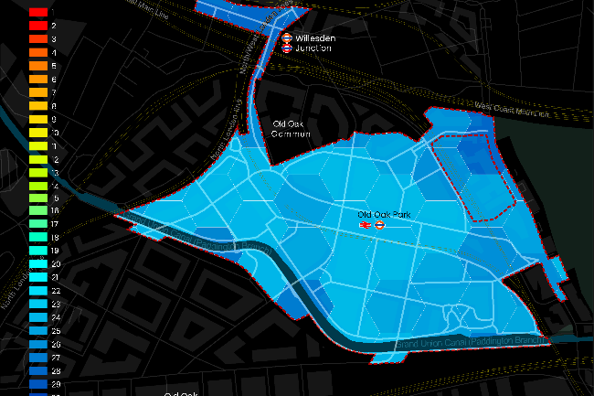
Limited Public Transport Access – Only 10% of the site had a high PTAL rating, restricting sustainable travel options.
Poor Connectivity to Key Amenities – Residents had limited access to healthcare, education, and retail, with a liveability score of 20/30.
Fragmented Street Network – The existing road layout required enhancements to optimise traffic flow and pedestrian movement.
Need for Quantitative Evidence – The planning team required data-backed insights to measure and justify proposed improvements.
Solutions
Spatial Design Hub applied a GIS-based approach to measure and improve connectivity:
Public Transport Accessibility – Modelled PTAL scores to evaluate transit improvements, increasing high-access coverage from 10% to 94%.
Proximity to Key Amenities – Conducted a 15-minute walkability assessment, leading to a 21% improvement in accessibility.
Street Network Optimisation – Used betweenness Centrality to analyse movement patterns and refine road layouts for better traffic and pedestrian flow.
Scenario Testing – Modelled alternative road alignments, ensuring the masterplan supports efficient connectivity and urban mobility.
Results
Public Transport Access Improved – 94% of the site now benefits from high PTAL, supporting sustainable mobility.
Better Walkability & Amenity Access – Accessibility to services increased by 21%, improving the liveability score to 25/30.
Enhanced Street Network – Scenario testing optimised key routes, improving traffic flow and pedestrian movement.
Data-Driven Decision Making – GIS analysis provided clear, measurable insights to guide masterplan refinements.
This project demonstrates the impact of spatial analytics in creating connected, accessible, and sustainable urban environments.