British Geological Survey
Coal mine gas emissions risk screening tool – a web-based solution for public bodies
Coal mine gas emissions risk screening tool – a web-based solution for public bodies
Details:
- Company: British Geological Survey
- Client: North Lanarkshire Council and WSP
- Year: 2022 - 2025
- Region: Scotland
- Product: BGS information products and services for planning, BGS Geohazard information products
Service areas:
- Geographical information systems (GIS) and mapping
- Environmental and sustainability services
- Land search and assessment
Introduction
The British Geological Survey (BGS) has launched a pioneering ArcGIS web map application that allows local authorities to rapidly and reliably assess gas risks from abandoned coals mines. As the world’s first decision-support tool of its kind, it transforms how mine gas hazards are evaluated—accelerating planning processes, strengthening public safety and expediating the development of new homes.
Challenges
Scotland’s long coal mining history has left a hidden legacy underground. Although little evidence of the industry remains above ground today, thousands of kilometres of abandoned mine workings lie beneath areas now earmarked for development. When assessing planning applications, local authorities must evaluate the risk of gas emissions from these historic mines and ensure suitable mitigation measures are in place to protect people and infrastructure.
The importance of this process was underscored in 2014 in Gorebridge, near Edinburgh, where around 200 residents of a new housing estate experienced nausea and headaches caused by elevated carbon dioxide levels from disused mine workings. Ultimately, 64 homes had to be demolished.
The importance of this process was underscored in 2014 in Gorebridge, near Edinburgh, where around 200 residents of a new housing estate experienced nausea and headaches caused by elevated carbon dioxide levels from disused mine workings. Ultimately, 64 homes had to be demolished.
Solutions
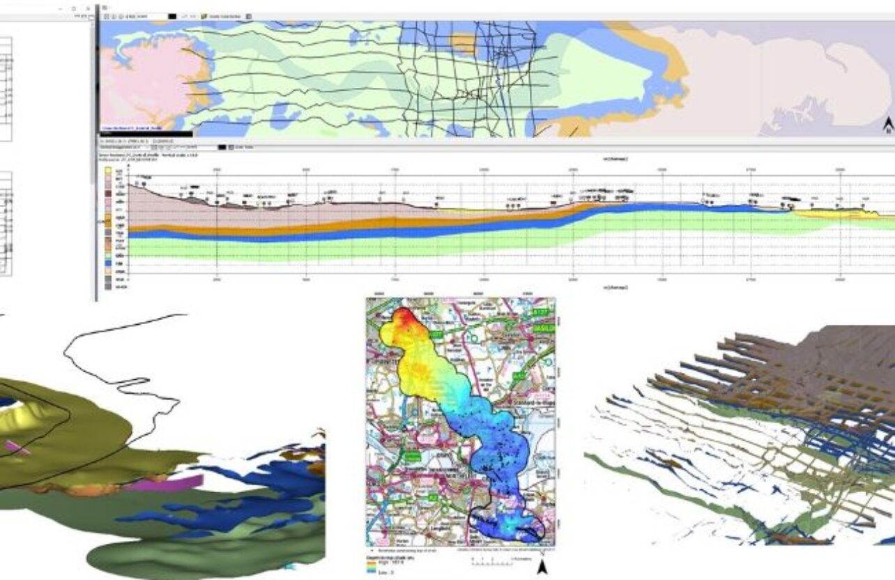
Following CL:AIRE’s national guidance on mine gas risk assessment, the British Geological Survey (BGS), WSP, and North Lanarkshire Council developed a GIS-based tool for early-stage screening of mine gas risks.
Previously, assessments were manual and time-consuming. BGS built a rapid prototype in weeks and refined it over six months using ArcGIS Experience Builder and ArcGIS Online. The tool integrates BGS geological data with publicly licensed datasets from the Mining Remediation Authority. Hosted on the council’s ArcGIS Online system, it is now used daily by pollution control and planning officers to inform decision-making.
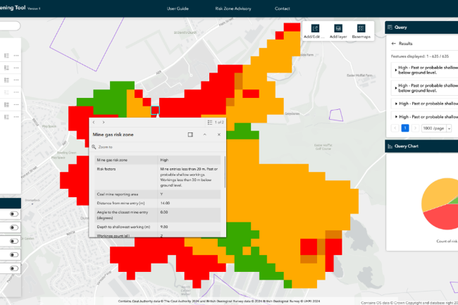
Users simply draw site boundaries, and the tool generates colour-coded risk scores for each 50 m² grid cell, with the option to explore to detailed data like nearby mine entries and boreholes. Outputs support internal decision-making and can be shared externally.
Previously, assessments were manual and time-consuming. BGS built a rapid prototype in weeks and refined it over six months using ArcGIS Experience Builder and ArcGIS Online. The tool integrates BGS geological data with publicly licensed datasets from the Mining Remediation Authority. Hosted on the council’s ArcGIS Online system, it is now used daily by pollution control and planning officers to inform decision-making.
Users simply draw site boundaries, and the tool generates colour-coded risk scores for each 50 m² grid cell, with the option to explore to detailed data like nearby mine entries and boreholes. Outputs support internal decision-making and can be shared externally.
Results
The mine gas risk screening tool enables the following benefits:
• Faster planning decisions. The tool significantly reduces the time needed to assess mine gas risks, enabling quicker, evidence-based planning decisions.
• Greater confidence and consistency. By providing a single, standardised method of assessing mine gas risks, the tool builds trust among councils, contractors, and developers.
• Improved public safety. The tool simplifies the complex task of mine gas screening, ensuring consistent risk evaluation early in the planning process—helping prevent incidents like Gorebridge.
• A model for other mining regions. Believed to be the first tool of its kind globally, BGS plans to build on this success and extend similar services to other mining regions.
The mine gas risk screening tool is helping to inform development decisions and planning applications by giving consistent, accurate information to officers and planning applicants. The tool also reduces the need for additional investigations where there is a negligible risk, allowing development to progress more quickly.
Mark Findlay
Pollution control and public health manager at North Lanarkshire Council.